gps

Garmin Nuvi 1450/1490 LMT GPS Reivew
Difference between Nuvi 1450 LMT and 1490 LMT:
The newest GPS from Garmin -- 1450 and 1490 LMT. There are only two difference between the two.
1) 1490 has Bluetooth, 1450 does not
2) 1490 is black. 1450 is silver
Otherwise the two units are totally
identical. Both is 5 inch screen, made of the same materials.

Nuvi 1450 and 1490 LMT features
Aside from the standard GPS features (e.g. Map for North America/Navigation to address/6 millions POI/Day night auto switch/Announce street names.. etc), there are a few extras:
1)
LMT
LMT stands for Life time traffic and map updates. It means you can get free
traffic information (construction & traffic jams) from major cities around
North America. You can also get unlimited map updates from Garmin (they usually
have map updates annually).
a.? Traffic Update
How useful this feature is depends on where you live. Here in Vancouver this
feature is pretty useless, not that we have much traffic jams here. We got a
bit of road construction here and there but otherwise it?s smooth sailing most
of the time. To find out if your city is covered/how much it is covered, you
can visit the link here?
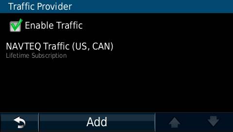
b. To view the traffic information, you have to switch to the traffic map (which will turn the whole screen grey). I can?t really test the traffic feature objectively because we seldom have traffic jams here where I live. You can also do a traffic search which will give you information about the nearest traffic information (I?ve seen a couple of road construction icon on the map before).
c.? Map Update
Garmin usually update their maps about once every year. Here?s the catch for
the map update, the 2010 maps are not really 2010 maps. I have noticed a road
change updated in 2009 is not reflected on 2010 map, but this is as expected.
Neither NAVTEQ nor TeleAtlas (map providers) update their map so frequently.
This is same for both Garmin and Magellan. TomTom maybe a bit of different,
because they have user updated information, but whether the road change concern
you is updated or not cannot be reliability predicted. I do notice a 3 year old
road change is correctly updated in Garmin map 2010, which is good. The life
time map update seems to be a good idea. But really, a GPS only last as long as
your GPS battery dies completely (maybe 3 or 4 years?). And we probably really
need maybe 2/3 map updates within those years. Assuming each map update cost
around $50, the life time map update worth a value about $100 to $150 in value.
It?s a saving if you absolutely have to have the most updated map, otherwise,
most people can survive without a last minute (actually last 2 year) map
update.
2) Power on
a.? The power button is at the top, you can manually switch on the unit with the power button.
b. The GPS will automatically power on when you start your car
(assuming it is ?connected to the power cable). It will show you the
disclaimer first, you can press OK to continue or wait a few second until it
get bored and disappear by itself. You will then be greeted with the Main Menu
showing ?Where to and ?View Map?.
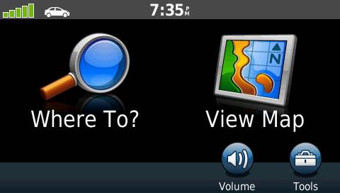
You don?t really have to press anything and when you start driving, it will
automatically switch to the map menu. One problem is if you park your car in an
underground parking, it will show you a message saying it can?t find the GPS
signal and display a dialogue box. This is fine, but that dialogue box will not
disappear by itself even after the GPS find the satellite, you have to push the
?OK? button with your finger to make that box goes away. That is rather
annoying. In Magellan or other GPS, it simply gives a beep when it lost
satellite or satellite is not found, why Garmin has to be so dramatic and bring
up a dialogue box to distract the driver?
c.? The power cable also act as the traffic receiver, so you may replace it with a regular USB cable but it won?t give you traffic information unless you use the original cable.
d. The USB power cable is located at the back, close to the bottom but not exactly at the bottom, so it is possible to put the GPS on a flat surface unlike most of the new Magellan or TomTom GPS. (I don?t think it will bother most people but being able to put the GPS on a flat surface is a critical requirement for me)
3) Display
a.? Physically the screen can be read easily day or night, nothing new here.
b. Main Menu Display.
Classic Garmin menu, showing ?where to and ?view map?. It is not as annoying
as the old Magellan which has hundred layer of menus, but it is also not as
convenient as the new Magellan GPS with the 1-Click menu. I really hope they
can be like the new Magellan GPS adding some customizable buttons on the main
menu so you can click once to find some favorite destination (e.g. work)
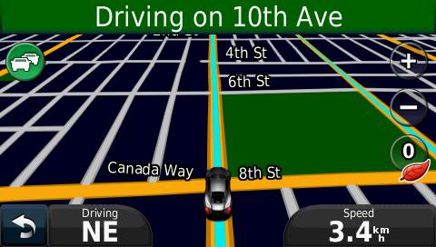
c.? Navigation Field
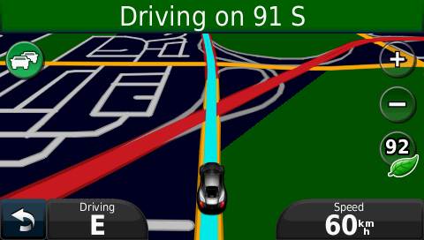
In the navigation screen, it can only display two items and one of them has to
be speed? this is rather limiting, you can, of course, turn on the detail display
but that take away half of the screen to display four items (which is a bit too
much).
 Ideally I hope they can display 3 items, arrival time, distance to
destination and maybe speed. Right now I have to choose either to display
arrival time or distance but not both. The speed field supposed to tell you the
maximum speed limit for a particular highway but so far I have never seen it
display anything (we only have two high way here, so it might not be the best
place to test this feature).
Ideally I hope they can display 3 items, arrival time, distance to
destination and maybe speed. Right now I have to choose either to display
arrival time or distance but not both. The speed field supposed to tell you the
maximum speed limit for a particular highway but so far I have never seen it
display anything (we only have two high way here, so it might not be the best
place to test this feature).
d.
Street name display
In the old Garmin GPS, they used to display the street name of the street you
currently travelling on in the navigation screen but right now it only display
the next turn (e.g. Turn right at Main Street). But actually the story is a bit
more complex. Yes the little green line on the top only display the next turn
when you are in navigation mode. When you are not travelling to any particular
place, it will actually display the street name you are currently on? most of
the time? If the street you are on happens to be a highway, it will usually
display the next exit. So there is some intelligent built in to that little
green line. Overall I think the approach seems to be appropriate.
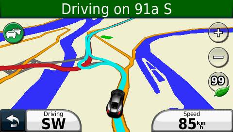
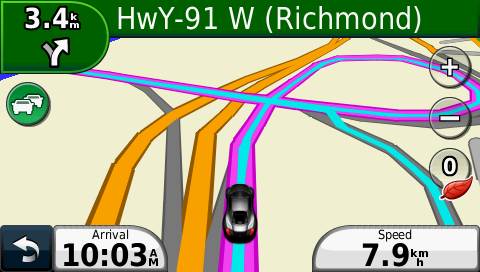
e. Navigation Screen
You may not notice any difference but it is actually a intelligent map screen,
a bit different from the traditional linear map screen you see on the old
Magellan or Garmin GPS. It lets you see a bit further away. Even though the
resolution is exactly the same, but it display the closer location a bit larger
and distant location a bit smaller,? so it fit a bit more on the screen.
It also selectively omitted street name. It can be annoying at first but as
soon as you understand the logic behind, it seems to make sense somehow. During
navigation mode (i.e. when you navigate to some destination), it only display
major street names and the street you need to turn into, all other minor street
names will be omitted. When you are on a highway, it will omit most street
names since you won?t have direct access to those streets anyway. When you are
not in a navigation, it will display most street names except those you don?t
have direct access to (e.g. a blocked street). So yes, it?s a bit disconcerting
at first but it does make the screen look cleaner?
f.
Browse Map Screen
Again some street names for some minor streets are omitted. This time I don?t
think very positively on this feature. When browsing a map (in 2D mode), it
really should display everything, often our destination contains some minor
lane or driveway. It will display the street name when you click on a point but
it does make the map browsing experience a bit awkward. When you click on a
point, a dialogue box will pop up, it blocks a bit of information behind the
dialogue box, but to see the missing information, you simply need to scroll a
bit away? Some people seems to hate the popup box, but I think it?s acceptable.
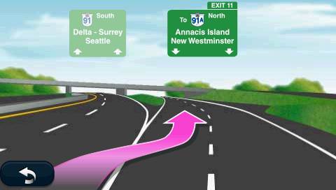
g.? Lane assist
When available, the GPS will show you which highway lane to take. It usually
only works on highway and only some particular highway. I have only seen it at
one place. It does its job, the display on your GPS is pretty much identical to
the sign you see outside your windshield? same order of words and even word
alignment.
4)
Speak Street names:
Both 1450 and 1490 speaks streets names, though not in the most sexy voice...
it is rather robotic, but loud and clear enough. It can also speak other
foreign language, but speaking street name is only available at the English
Voice. Pronunciation is generally accurate. It speaks twice before a turn, one
right at the turn, one way before the turn (depends on speed). It also talks
when it do recalculation and lost satellite signal which is rather annoying, I
would rather it just give a simple beep at those occasions.
5) EcoRoute
a.? It may not sound very interesting, but it?s actually more useful than it sounds.
i. EcoScore: It gives you a score base on how you drive and display a dried leaf (when you waste gas) or a green leaf (when you drive more efficiently). Looks very similar to those you find in the HyBrid vehicles. But the score itself is rather pointless and not particularly accurate. For the GPS has no way to know whether I?m pressing the break or simply decelerate naturally which makes a big difference in fuel consumption.
ii. Fuel Consumption and Mileage Calculation: The fuel consumption and mileage calculation on the other hand is a rather useful function. Every time you turn off the engine (i.e. when GPS lose power), the GPS will tell you how many miles you drove, how much gas you spent and how much money it cost you for the trip you last travelled. It also recorded those information in memory so you can later retrieved them with your computer. They are in CSV file format so you can import them to Excel. It also has a at the pump menu where you can record the current gas price which the previous information were calculated upon. After you enter the volume of gas spent, it will give you your average mileage for the tank. The distant travelled is automatically calculated so it can only be useful if you turn on your GPS every time you turn on your car.
6) TrackLog
a.? It used to be a feature only available on higher end Garmin models, but both 1450 and 1490 has the ability to record track logs. It?s like a bread crumb, the line will follow you wherever you travel. You have the option to display/hide the track log. Besides the obvious function that it will allow you to track where you travel and download the information onto your computer and plot it on a mapping software like Google Earth, it also have some practical use. Say you want to deliver brochure to a neighborhood, by displaying the tracklog on the GPS screen you can see which street you have already covered and don?t need to travel them twice. Or say you want to see the Christmas lights around a particular residential area,? you can enable the track log and drive freely and not worry about traveling the same street twice.
7) Pedestrian Mode
a.? It has driver mode, pedestrian mode and off road mode. If you purchase the city explorer (around $10/city), you can travel to a destination using public transport. If you are on a bike, sometimes you might want to use the off road mode (assume your city allows you to bike on pavement).
8) Address entries
a.? Not much new here. Same old same old. The only improvement I see is the numbers and alphabets are in the same screen now so you don?t have to switch back and forth. It also has Multilanguage keyboard but I suppose most street names in North America is in English.
b. The address entry is not as convenient as the Magellan screen. In Magellan, it will disable the characters that is not available in the street name selection. No such feature in Garmin. But you don?t really have to enter all letters, as long as you narrow down the selection to a reasonably small group, it will jump to the group instead of requiring you to type the whole thing.
c.? You can select a street intersection but you can?t simply select a street (so if you only know the name of one street, you are out of luck). You can select by postal code, street address, previous address, city name? etc. You can save any entry as favorite so it can be found easily later on. When you browse your favorite entries, they are sorted according to nearest distance.
d. POI
There are 6 million POI. How updated they are depends on where you are. A few
years ago, my Magellan GPS don?t even have the location of BestBuy in the 6
million POI. The Garmin POI at least have BestBuy which should be very obvious.
Some places the POI are completely empty (e.g. Harrison Hot Spring near
Vancouver), even though there are hundreds of restaurants around (and for many
years). I guess neither the NavTeq nor TeleAtlas staff visit those towns.
Magellan GPS has AAA POI support but the Garmin GPS does not support AAA POI.
e.
Custom POI

Like previous model, the ?Extra? menu allow you to import extra GPS from your
computer. It?s not very at first but you have to go to extra POI and click on
Custom POI to find your stuff. There seem to be an extra level of useless menu
but it may have other reason for being there.

9) Route Finding
a.? Sometimes it get off the highway too early.
b. It has shortest route, shortest time but it does not have a ?stay on highway? option like those Magellan GPS.
c.? But it also does not make stupid mistake like those Magellan GPS.
Even though the route found by Garmin may not be the most optimized, they at
least? make some reasonable calculation. Unlike the buggy Magellan GPS,
which sometimes make strange U-Turn request, sometimes randomly detour you to
some strange intersection. I haven?t noticed similar bugs in Garmin. No strange
detour at least. One major reason for picking Garmin over Magellan is because
Magellan recently switching their map providers from NAVTEQ to TeleAtlas. Both
map company have similar map coverage (although NAVTEQ was allegedly have more
coverage in N.A. while TeleAtlas is better at Europe), the major problem is
Magellan didn?t bother to update their routing logic after they switch the map
provider. As a result, a lot of strange detour causing a lot of user uproar. So
far the route finding in Garmin is subpar but at least it is not broken.
10)
Software update/Bug Fix
Another reason for me to pick Garmin over Magellan is the software update.
Magellan in my experience are not very good at updating their firmware, they do
update it, but not as frequently as Garmin. They also have a shorter support
update, they often stop updating the software before all bugs are fix. Garmin
on the other hand even include new features in their update (at least for my handheld
GPS).
11)
Compare with higher Garmin GPS models
This is neither the cheapest model nor the most expensive model, I paid about
CDN$149 for the 1450 LMT while the 1490 LMT only cost $179. Some ?high end?
feature not available in this model includes?
a.? Better screen, some high end Garmin model have some fancy display with higher resolution (800x430) instead of (480x260)
b. Automatic route recognition. Say you drive through main street to work, higher end Garmin GPS will automatically recognize such route as soon as your drive through main street and it will give you the estimated time of arrival (without the annoying prompt)
c.? Routing base on time of day. Higher end Garmin GPS can be trained so they know which route is better base on the time of day.
?
If you would like, you can purchase Garmin Nuvi 1450 LMT or Nuvi 1490 LMT from Amazon. It?s the same price if you go there directly, but by clicking on my referrer link, you give me some support for this blog.
?
?
Garmin Oregon 450 - Birdseye View
It was said that when technology became so advance, it becomes indistinguishable from magic.
I am going to show you some magical features of Garmin Oregon 450 GPS.
By the way, most of these features also works in Dakota, Colorado and other version of Garmin Oregon.
- The first feature is "Birdseye View"
Imagine you are a spy going to a foreign city, in order to find your target, you will need a device that will show you the satellite image of the city as it was seen by a bird from several meters above ground. That device will be a Garmin Oregon/Dakota GPS.- In short Garmin Birdseye View is Google Earth in your pocket.
- Garmin Birdseye view is a subscription service. One year subscription costs around US$30. It includes unlimited download of maps anywhere in the world.
- In theory, you can do all these with custom map using Google Earth,
that is a poor man's version of Birdseye view. But there are two
problems..
- Custom map does not support dynamic zoom resolution, you will be seeing the same resolution no matter what zoom level you are currently at
- Custom map takes a lots of time to create, by the time you finish, you could have earned the $30 by doing a part time job.
- To use Birdseye view, do the following:
- Connect your GPS to your computer. Of course, you need a compatible device, e.g. Garmin Oregon, Dakota or Colorado.
- Start Garmin Basecamp. You would need to download Garmin Basecamp 3.01 or newer version (any older version does not work with Birdseye view). The Basecamp software is free.
- In Basecamp, highlight a list from the library. That will be the place the birds eyes view will be saved.
- Select New Birdseye view
- Browse to a region you would like to create the satellite imagery. It is not limited to North America. It can be anywhere in the world, for example, I select Casablanca in Morocco.
- With the New-Birdseye view active, draw a rectangle on the region you would like to select.
- Since I don't have an active subscription, it will only create a postage stamp sized demo version satellite image.
- Follow the wizard and select send to GPS.
- By default, the map is downloaded to the device. But you can copy the map to your SD card after the download is completed. So each download is limited to the memory of your device (which is usually 800MB)
- Some Birdseye view images are more detail than Google Earth.
- Since this is a subscription based service, I am not so sure if you can still view the image you downloaded after your subscription expired.
That's it. Thanks for listening.
Garmin Oregon 450 - Geotag Photos
It was said that when technology became so advance, it becomes indistinguishable from magic.
I am going to show you some magical features of Garmin Oregon 450 GPS.
By the way, most of these features also works in Dakota, Colorado and other version of Garmin Oregon.
- Now you may ask how to GeoTag the photos? To do that you would need
Garmin Basecamp...
- Start Basecamp
- Select a track
- Right click and select GeoTag Photos.
- Choose a folder where your photos are located...
- and then select OK. After it is GeoTaged, you will see the photos on your Basecamp maps (and even the maps within your GPS)
- Garmin Basecamp will only GeoTag the jpg images, if you want to GeoTag raw images, you would need to buy a software like Robot Geo.
it. Thanks for listening.
Garmin Oregon 450 - Auto Archive Tracks
It was said that when technology became so advance, it becomes indistinguishable from magic.
I am going to show you some magical features of Garmin Oregon 450 GPS.
By the way, most of these features also works in Dakota, Colorado and other version of Garmin Oregon.
- archive tracks feature
- with the newest version of Garmin Oregon 3.3 update, a new track archive feature is added.
- You can goto the setup screen and choose auto archive.
- It will save your tracks everyday and even after a very long trip, you still retain the tracks to GeoTag your photos.
- That feature will also log the tracks when you are using stopwatch. So it is extremely useful when doing personal training.
That's it. Thanks for listening.
Garmin Oregon 450 - Import from Google Earth
It was said that when technology became so advance, it becomes indistinguishable from magic.
I am going to show you some magical features of Garmin Oregon 450 GPS.
By the way, most of these features also works in Dakota, Colorado and other version of Garmin Oregon.
- Import waypoints from Google Earth
- Garmin Basecamp now allows direct import from Google Earth KML or KMZ files, so you can create waypoints using Google Earth and import them directly to your GPS.
- The advantage of using Google Earth to create waypoints is they have a lot of POI that is not available on any GPS software
- For example, they have the user photos from Panorama, it is very useful to create waypoints that is not included on any maps
- They also have the Wikipedia entries of important monuments, so not only you can go somewhere but you can also read up on the details within your waypoint.
- And of course, the normal bus station location and hotel locations which is standard on any mapping software.
Garmin Oregon 450 - Custom Map
This video shows how to create a custom map using Garmin Oregon 450
(also works on Oregon 300/300t, 400/400t, 450t,
500/550/550t, Dakota 10/20 and Colorado)
- Find any map, save to jpg
- Start Google Earth
- Add - Image Overlay (Shift-CTRL O) 4) Adjust image positions
- Connect Garmin Oregon
- Save to /Garmin/CustomMap (may need to create the folder)
You can use any map you like, tourist maps/campus maps/trail maps... etc